
We asked Patricia Schultz, author of 1,000 Places to See in the United States and Canada Before You Die, for a few of her favorite outdoorsy destinations in California. Join us on a journey through the natural wonders of the Sunshine State.
The Pacific Coast Highway and Big Sur
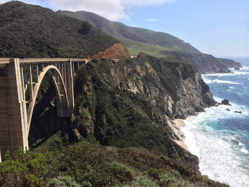
Known by those not from these parts as Route 1, the Pacific Coast Highway is America’s dream drive, offering stunning coastal views along almost all of its twisting dramatic route from California’s northern border with Oregon (where it joins with Route 101) to its southern boundary with Mexico. Most of the two-lane PCH runs through gorgeously isolated terrain, and frequent turnouts and vista points provide ample opportunity to soak in the coast’s rare and astounding natural beauty. You can head south from L.A. to San Diego, or take the traditionalist’s route north to San Francisco and even beyond, past the 19th-century fishing-town-turned-artists-colony of Mendocino.
From the heart of L.A. head west to Santa Monica then follow the coast to Malibu, where you’ll already feel a world away. Seventy miles up the road, you’ll skirt the environs of Santa Barbara at the base of the dramatic Santa Ynez Mountains. Farther north, the fabled PCH begins to unfurl at its most majestic, carving an awesome ribbon of highway 500 to 1,000 feet above the roaring Pacific. Extolled as America’s road trip extraordinaire, the wild and rugged 90-mile stretch from the Hearst Castle at San Simeon, past Big Sur and on to the Monterey Peninsula is the uncontested high point.
Bounded by the rugged Santa Lucia Mountains to the east and the Pacific to the west, Big Sur remains a remote wilderness and natural masterpiece. “A place of grandeur and eloquent silence” is how Henry Miller, the author of Tropic of Cancer, described his adopted home. Virtually inaccessible before the PCH was built with the help of prison labor and New Deal funds, Big Sur saw more tourism and second homes when the highway finally opened in 1937. Its beauty drew writers and artists like Miller, whose books and photographs can be explored at the Henry Miller Memorial Library, and alternative thinkers, some of whom later helped found Esalen Institute.
Fiercely protected by its 1,500 residents, Big Sur has a dramatic loneliness about it, with angry ocean breakers on one side and a narrow curving road that snakes along the edge of the mountains. Pfeiffer State Beach is breathtaking—in fact, there’s precious little around here that’s not. Stop to take it all in with a drink or dinner at the well-known Nepenthe, with its outdoor patio suspended 800 feet above the surf.
California White Water
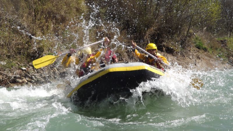
Spilling down the western slope of the Sierra Nevada at breakneck pace, the American, Yuba, and Kern rivers offer some of the most exhilarating white-water rafting anywhere in the world. The sheer slope of the mountains translates into wild rides through Class III, IV, and V rapids, with lots of rocks to dodge and narrow channels to pass through. Guided trips (recommended for all but the most highly experienced rafters) of five or six people promise you and your boatmates an emotional journey through the tumultuous rapids that can take you from fear to profound joy in just a few hours.
Three hours east of San Francisco, the American is the easiest of the three rivers despite its big, crashing, roller-coaster waves. The boulder-strewn South Fork (also known as Gold Rush River) is the most famous and most popular of the river’s three forks, a Class III intermediate river that can truly exhilarate with its sheer drops at Troublemaker and Satan’s Cesspool. More skilled or adventurous rafters can run the North and Middle forks of the American, which traverse the steeper mountains at higher elevations with many Class IV rapids. Farther north is the more demanding Yuba River, a Class IV+ run where you’re either in a rapid or on the brink of one the entire day. The Lower section is doable for the adventurous first-timer, though beware the aptly named Maytag, a steep set of rapids that can flip you around (or be bypassed on foot). The upper Yuba, a Class V gauntlet of churning white water and steep drops, is for white-water veterans only.
At the southern end of the Sierra Nevada range is the Kern River, one of the nation’s “Wild and Scenic Rivers” (an official designation for the country’s most beautiful undammed rivers). This jewel runs 60 miles through the heart of Sequoia National Forest, offering everything from mild waves to wild rides. Most popular is the two-day trip on the Lower Kern, which tumbles inside a narrow granite canyon through a series of adrenaline-pumping Class IV rapids. During late spring and early summer, the Upper Kern offers a heart-stopping series of four rapids that takes only a couple of hours. Another two- or three-day trip down the Forks of the Kern, one of America’s most challenging and starkly beautiful rivers, hurtles through some of the steepest and most frightening Class V rapids one could ever hope to survive. Last but certainly not least, the Tuolumne and Merced rivers near Yosemite combine the thrills of California’s white water and the scenic beauty of the state’s river canyons.
Yosemite National Park
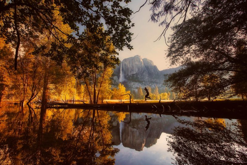
“No temple made with hands can compare with Yosemite,” wrote naturalist John Muir, the conservationist whose work led to the founding of Yosemite National Park in 1890. Most of the park’s natural attractions have become icons of the American landscape, immortalized by the photographs of Ansel Adams. Who doesn’t recognize the bald image of Half Dome, Yosemite’s 8,839-foot trademark peak? Or El Capitan, the largest single granite rock on earth, rising 3,000 feet from the valley floor (twice the size of the Rock of Gibraltar) and drawing rock climbers from all over the world? Venture deeper into the park and visit the magnificent Yosemite Falls, the highest on the continent at 2,425 feet.
Millions converge in high season on this temple of nature, most heading for the star attractions and awesome beauty of the mile-wide, 7-mile-long Yosemite Valley, cut by the Merced River and guarded by sheer granite cliffs and domes, rising 2,000 to 4,000 feet from the valley floor. Avoid the park’s notorious summertime people-jams by exploring the backcountry—the wilder 95 percent of the 1,190-square-mile park.
Yosemite’s 750 miles of trails, ranging from easy day hikes to challenging overnight trips, can be covered by horse, mule, or on foot. One of the most popular is the moderately strenuous Mist Trail, offering a close-up view of 317-foot Vernal Fall and the 594-foot Nevada Fall. The most ambitious hikers tackle some or all of the 211-mile John Muir Trail, which travels end-to-end through three national parks—Yosemite, Kings Canyon, and Sequoia—along the backbone of the Sierra Nevada. Named for the founder of the Sierra Club, the trail was created between 1915 and 1938 and runs from the summit of Mount Whitney in the south to the Yosemite Valley in the north.
For those who prefer to remain in the car, the park offers 214 miles of paved roads. (Head to Glacier Point for spectacular views of the valley below.) Or experience Northern California’s great white-water rafting on the Merced River, where rafters can find Class III or IV rapids over a 28.3-mile stretch, or on the Tuolumne River, just outside the park, which offers over 18 miles of scenic Class III or IV rapids.
Santa Catalina Island
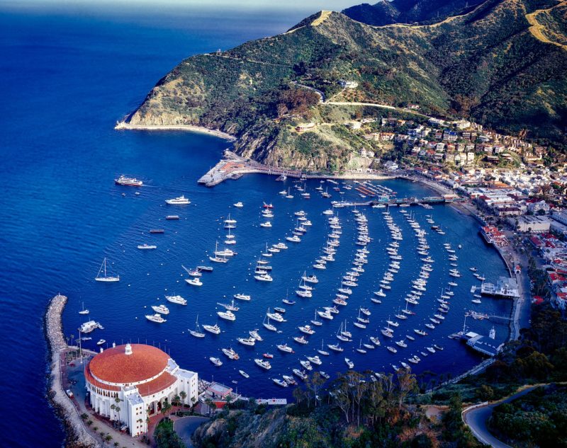
Just 26 miles from the coast of Southern California, the jewel-like island of Santa Catalina seems worlds away from the bustling urban sprawl of Los Angeles. It was first purchased and developed by William Wrigley (of chewing gum fame) in 1915, as a popular resort destination for movie stars and Hollywood folks seeking weekend escapes. Today, it’s still an oasis that recalls a simpler time and a glimpse of what undeveloped Southern California once looked like. Its tiny town of Avalon—the only real town on the island—is characterized by Spanish 1920s architecture and a sprinkling of little touristy souvenir shops. It backs up to what is essentially one big nature preserve covering 88 percent of the island, deeded to Catalina Island Conservancy by Wrigley, where feet, bikes, golf carts, and a trolley are the only means of transportation.
Avalon’s stand-out building is the glamorous 1929 Casino. Never actually a gambling place, it was a ballroom frequented by Catalina’s early visitors and jumped with the music of every big band of the 1930s and ’40s. The ornate art deco landmark features a movie theater, and each month it honors its heritage when an organist plays its historic instrument; it’s also the venue for October’s popular jazz festival. There’s little more to do in the town than catch a movie and meander the shops. Take a hike or an inland tour (the latter is the only way visitors are allowed to explore most of the island’s interior), or try zip-lining. And yes, those are bison you see grazing, descendants of those brought over in the 1920s when Westerns were filmed here.
For a glimpse of life at the top, head up to the former Wrigley mansion that sits 350 feet above town, now the Inn on Mt. Ada. Built in 1921, and named after Wrigley’s wife, the grand Georgian Colonial estate entertained the likes of Calvin Coolidge, Warren Harding, and the then Prince of Wales in its heyday. If you don’t join the ranks of lucky guests spending the night in any of the mansion’s six sun-soaked bedrooms with ocean or harbor views (the very reason Wrigley chose this site), at least stay for lunch on the wrap-around terrace or indoors dining room—the only way you will have access to the property.
Sequoia and Kings Canyon National Park
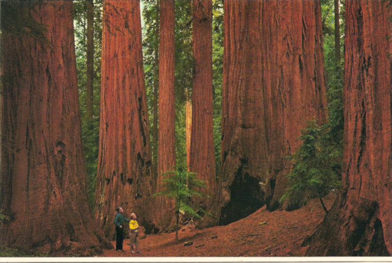
Home to ancient groves of giant sequoia, towering granite peaks, and the tallest mountain in the Lower 48 states, Sequoia and Kings Canyon National Parks, located in central California on the western flank of the Sierra Nevada range, are truly the land of behemoths. Only one road, the Generals Highway, loops through the parks. But if stay in your car you’ll miss the grandeur of the experience: feeling yourself to be a small and humble creature at the ankles of the giant sequoias, the world’s largest living things.
Legendary naturalist John Muir described these massive trees as “the most beautiful and majestic on earth.” Sequoias achieve their size because they grow quickly over a long lifetime, and they live so long because a 6-to-8-inch-thick armor of bark protects them from both insects and fire. (They do have one weakness—a shallow root system—and the main cause of death is toppling.) Created in 1890 to prevent logging, Sequoia was declared the second national park in the U.S. Adjoining Kings Canyon was added in 1940. Because Sequoia and Kings are more remote than nearby Yosemite, they’re much less crowded, and give visitors the priceless feeling they’ve really gotten away from it all.
The mountaintop plateau of Giant Forest, with its thousands of giant sequoias, has always been the heart of Sequoia National Park. The Redwood Mountain Grove is the largest of the world’s 75 majestic groves, 29 of them located in the park, and each pervaded by a mystic quiet that one has to experience to fully appreciate. The General Sherman, the largest tree in the world by volume, is 2,500 years old, 275 feet high, and has a circumference of 103 feet. Benches invite you to sit and contemplate its mass—the trunk alone weighs nearly 2.8 million pounds, with its first branch beginning 130 feet above the ground.
Other attractions include Mount Whitney, at 14,494 feet the tallest peak in the continental U.S.; the hiking trails of Mineral King, past waterfalls and lakes; the road through Kings Canyon, a beautiful U-shaped glacial ravine with granite pinnacles; and Crystal Cave, one of the 200 caves in the park, and the only one you can tour. A 50-minute tour led by a guide brings alive the eons of time it took to form these fantastical shapes.
And don’t forget to check out the book!
 About the Book:
Covering the U.S.A. and Canada like never before, and for the first time with full-color photographs, here are 1,000 compelling, essential, offbeat, utterly unforgettable places. Pristine beaches and national parks, world-class museums and the Just for Laughs festival, mountain resorts, salmon-rich rivers, scenic byways, the Oyster Bar and the country’s best taco, lush gardens and coastal treks at Point Reyes, rafting the Upper Gauley (if you dare). Plus resorts, vineyards, hot springs, classic ballparks, the Talladega Speedway, and more. Includes new attractions, like Miami’s Pérez Art Museum and Manhattan’s High Line, plus more than 150 places of special interest to families. And, for every entry, what you need to know about how and when to visit.
“Patricia Schultz unearths the hidden gems in our North American backyard. Don’t even think about packing your bag and sightseeing without it.” —New York Daily News
Buy the Book
Amazon | B&N | Indiebound | Workman

No Comments